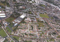
Throughout the 'Master'
Plan for Ballinacurra Weston it states:
" NB It is important to note that the area proposed for
regeneration in Ballinacurra Weston consist of the housing estates
of Clarina, Crecora, Beechgrove, Lenihan Avenue (part of), Byrne
Avenue, Hyde Ave/Road (part of) and Weston Gardens. It does
not include Punches Close, Hayden Villas, Weston Terrace, Rosbrien
Terrace/Road, Ryans Cottages or Donnellan's Buildings or the
ESB site."
This is because all
of the areas mentioned are within the legal remit of the Southside
Regeneration Agency but not all are currently targeted for regeneration.
Estimated Cost
of Regeneration:
Because Southill
& Ballinacurra Weston have been lumped together in the 'Master'
Plans there are no figures specifically available for the regeneration
of Ballinacurra Weston. The estimated cost of regenerating both
areas is as follows:
| Public Sector
Investment |
€647.5
million
|
| Private Sector
Investment |
€506.7
million
|
| Total |
€1154.2
million
|
Estimates for the
proposed future use of the ESB site and Rosbrien Road are not
included in the above figures.
Extract from the
'Master' Plan for Ballinacurra Weston:
In Ballinacurra Weston,
up to 350 new homes are to be provided, of which approximately
300 will replace existing homes. There are also a number of
sheltered or retirement housing units proposed in Southill,
and in Ballinacurra Weston.
In Ballinacurra,
5,000 sqm of new community uses are provided, including just
over 1,000 sqm of local retail/ employment uses.
Development in Ballinacurra
Weston is much more constrained by the site conditions, existing
routes, phasing requirements, and topography, and rather than
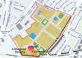
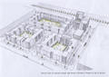
test a 'generic' block, indicative layouts were provided for
a number of selected blocks. These are shown opposite (click
here to view). The majority of new housing provided in Ballinacurra
Weston is replacement housing, with all housing to be demolished
and replaced on a phased basis.
This includes Lenihan
and Byrne Avenue. Up to 325 replacement homes, and a number
of sheltered housing units are provided. Approximately 200 of
these new homes are replacement housing, which follows the same
principles as the generic Block C explored previously. Densities,
site coverage, and percentages of public open space will be
similar. In some locations along Rosbrien Road (near the community
centre) or the new east-west community spine, building typologies
will be more similar to the generic block B, described in the
following pages, with apartment or town house typologies forming
strong frontages and enclosure to these routes, and providing
some mixed use at ground floor level. 54 of these units are
provided, with 80% (43) of these units provided as three bedroomed
homes.
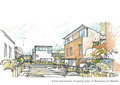
The western-most
development block provides continuous frontage along the Rosbrien
Road (near the community centre) and the new east-west route,
with a corner landmark building defining the entrance to the
site. Built typologies along this edge are typically three storey
terraced houses, with a four or five storey development to the
corner. The overall scale of the residential units, as they
travel northwards along Rosbrien Road has to contend with the
notable level differences between road level and site. Such
consideration should look at innovative solutions, such as entry
at first-floor level, in order to achieve a consistent overall
urban form.
The development of
this block should also consider its relationship with the existing
residential development to the northern edge and the possibility
of future development of the ESB site. The indicative block
layout proposes an access road which can be developed to provide
future connection through the ESB lands and the development
of the remaining portion of the block. Again, the level difference
with the ESB lands will need to be considered.
The central block
defines the northern edge of the new road that connects Rosbrien
Road and Byrne Avenue. It should provide strong and continuous
frontage to the route, and accommodate some active uses such
as local retail, the Credit Union, enterprise units etc, at
ground floor. This block will be one of the later blocks to
be built, and it butts against the boundaries of Weston Gardens.
The North-west edge
of the block has to contend with a steep embankment and the
boundary edge of the ESB lands. The overall block design makes
allowance for the future development of these lands to the north
and how it can stitch into the proposed fabric.
Towards the north
and north-east, development provides new frontages to Hyde and
Byrne Avenues, with a general principle of creating continuous
forms to these main routes. The interiors of the blocks are
based on a cluster pattern of two storey residential units organised
around a defined public open space with car parking accommodated
in the front area of these houses. The cluster is organised
around a shared surface where pedestrians have priority over
cars, and landscaped areas provide informal play spaces for
children.
Typically residential
units are two storey, with front gardens, and three storey elements
located at corners, at the junctions of key routes and open
spaces, and defining the entrance points to clusters. The proposed
open space located at the junction of Byrne Avenue and the proposed
new route offers a good opportunity for the creation of a defined
residential square or gardens. The overlooking edges to the
north and west will greatly influence the quality of this space
and work to define the study area as a whole.
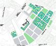
Three development
blocks have been shown dotted on the drawing opposite (click
here to view) , and this indicates the possible extension
of the urban structure, and the block layout, if the ESB lands
ever become available for redevelopment. The development capacity
of these sites has not been included in the calculation of housing
figures.
To view the
complete 'Master' Plans,"Limerick Regeneration: A Vision
For Moyross, Southill & Ballinacurra Weston and St. Mary's
Park" click here